Pioneering the
Stratosphere
Unlocking routine, unprecedented access.
The problem
Current platforms can't deliver routine, easy high-altitude access.
Satellites
Expensive & latent
Months to deploy. Billions to build. Fixed orbits that can't adapt to emerging threats.
Aircraft
Limited endurance
Only hours of flight time. High operating costs. Requires runways, pilots, and extensive logistics.
Drones
Can't reach altitude
Restricted to low airspace. Limited range. Narrow coverage. Vulnerable to weather and detection.
Space
Expensive, complex, long lead times
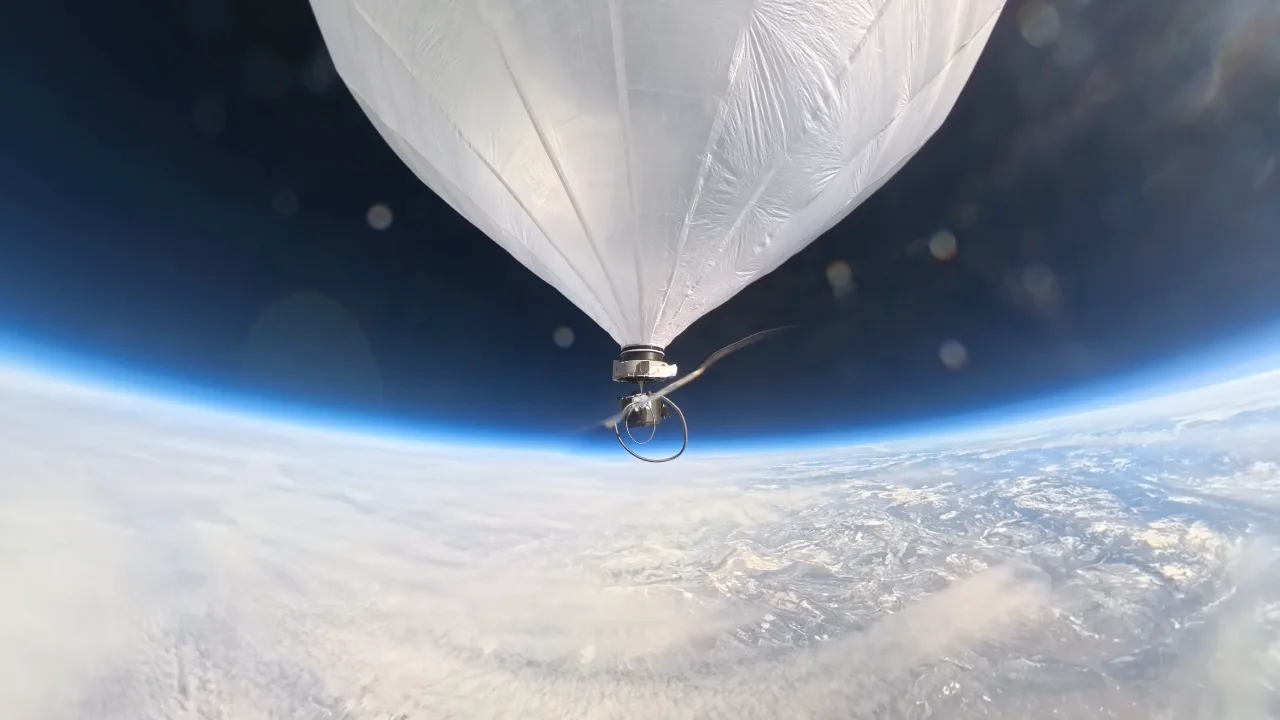
The Stratosphere
The optimal zone.
Aviation
Limited endurance, weather-dependent
Why the stratosphere?
The stratosphere sits in a sweet spot: high enough to avoid weather and airspace congestion, low enough for higher resolution and lower latency than satellites. It's been underutilized for decades because getting there—and staying there—was hard.
The Microballoon changes that. Launch in under 5 minutes. Reach 75,000 feet. Stay aloft for days. Our 20+ patents protect technology that makes stratospheric access routine instead of exceptional.
The result: persistent surveillance, communications relay, and sensing capabilities at a fraction of satellite costs—deployable on-demand, recoverable, and ready for the next mission.
Our Technology
Systems, software, and data products for routine stratospheric access.

Systems
The world's first precisely placeable stratospheric balloon. Launch in under 5 minutes, operate for days/months at 40,000–75,000 feet.
Explore Systems
Data
Multi-axis pointing platform with RGB, VNIR, and LWIR sensor options. Real-time data downlink from 75,000 feet.
Explore Data
Software
Mission planning, flight control, and data processing. Turn raw sensor data into actionable intelligence.
Explore SoftwareThe advantage
How we compare
| Platform | Cost | Deploy Time | Altitude | Endurance |
|---|---|---|---|---|
| Stratosphere | $$ | 5 minutes | 75,000 ft | Days/Months |
| Satellite | $$$$ | Months | 200+ miles | Years |
| Aircraft | $$$ | Hours | 40,000 ft | Hours |
| Drone | $ | Minutes | 400 ft | Minutes |
The Stratosphere combines the persistence of satellites with the flexibility of aircraft—at a fraction of the cost.
Three markets. One platform.
From defense operations to scientific research, the Microballoon delivers persistent stratospheric access across sectors that have waited decades for this capability.

Defense & Intelligence
Tactical ISR, communications relay, and persistent surveillance in contested environments. Deploy in under 5 minutes. Operate at 75,000 feet. Maintain coverage for days.
Explore Defense
Commercial & Data
High-resolution, real-time imagery and sensing for infrastructure monitoring, agriculture, and mapping. The coverage of satellites with the resolution of aircraft—at a fraction of the cost.
Explore Commercial
Science & Weather
Affordable, repeatable access for atmospheric research, climate monitoring, and near-space experimentation. Enabling discoveries that were previously impossible.
Explore ScienceFeatured in|TechCrunch•CNN•Popular Science•MIT Technology Review•SpaceNews
In the news
Ready to discuss your mission?
Whether you're exploring defense applications, commercial data solutions, or scientific research—our team can help you access the stratosphere.
